
Smart water conservancy
- In accordance with the Ministry of Water Resources' overall requirements of "demand-driven, application-oriented, digitally empowered, and capability-enhanced," we will construct digital twin river basins that run synchronously and interactively with physical river basins, water networks, and water conservancy projects in simulation. This will be achieved by taking physical watersheds as units, spatiotemporal data as the foundation, and digital models as the core, fully utilizing advanced technologies such as digital twins, cloud computing, big data, 5G, AIoT (Artificial Intelligence Internet of Things), and AI. The goal is to build a smart water resources management system with forecasting, early warning, simulation, and contingency planning functions, driving the datafication of water resources application scenarios, refinement of management, and intelligent decision-making.

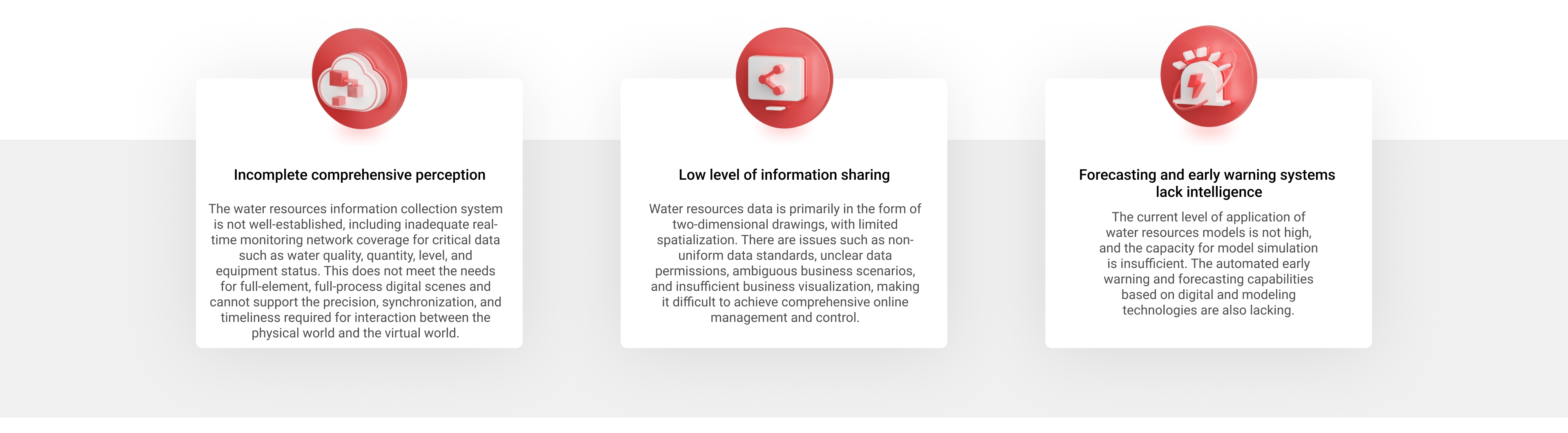
Industry Pain Points

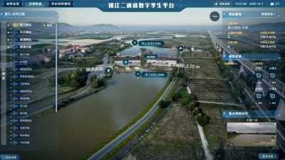
Using the next-generation GPU real-time rendering engine technology, we will accurately reproduce and render elements such as the sky, water bodies, vegetation, fluids, and water resources components in high detail. This will create a finely detailed, realistic, dynamic, and interactive three-dimensional digital twin of the watershed as a base layer.
Leveraging Internet of Things (IoT) technology, we can achieve real-time monitoring of critical safety indicators for water conservancy projects, such as deformation, seepage, stress-strain, etc. This enables a comprehensive overview of all monitoring elements in a single view, enhancing the real-time performance, reliability, and accuracy of dam safety monitoring.
Simulating a virtual avatar to navigate in first-person perspective along inspection routes, combined with real-time data from inspection points, IoT devices, and video surveillance, allows for reservoir operation inspections that are not limited by time, environment, or weather conditions. This approach significantly enhances the efficiency of the inspection process.
Through the construction of three-dimensional information models for water conservancy assets, these models can be linked to asset management systems to achieve digital, intelligent, and visual management of water conservancy assets. Additionally, this approach leverages the advantages of three-dimensional spatial simulation to enable the visual disassembly of key assets, supporting simulation training and equipment status management.
Forecasting forms the foundation, integrating the entire process models of "precipitation-production-runoff-convergence-evolution." It employs techniques such as rainfall animation and isosurfaces to provide intuitive and dynamic forecasts of precipitation at different lead times within the basin, as well as real-time monitoring and accurate forecasting of key elements such as water levels, flow rates, and water volumes at critical nodes.
Early warning acts as the vanguard, defining warning factors such as rainfall volume, water level, and flow rate. Based on the data platform's capabilities, it establishes a real-time, intelligent, and round-the-clock early warning mechanism to improve the timeliness and accuracy of warnings for water-related risk events.
Pre-execution simulation is the critical component, leveraging data-driven three-dimensional dynamic flood evolution simulation technology to simulate flood risks in the basin. This enables scientific and precise risk assessment, planning, and decision-making, reducing losses from flood disasters.
Contingency planning serves as the ultimate goal, integrating various flood control plans, dispatch rules, and expert experience. It expands the functionality to automatically generate plans and compare multiple scenarios.
Real-time rendering of the watershed
Four-preparedness applications in water resources management
Engineering Safety Management
Intelligent Patrol Inspection
Digital Asset Management


Digital twin-enabled scenarios, starting from now.


Email:service@meixxx.com
Contact us:400-9688-692
Online Sales :13395742337
Official Account
Channel
Online Sales